Sport, Health & Wellbeing
UC’s 30th anniversary: Intrepid cartographers of public health
At the Australian Geospatial Health Lab (AGeoH-L), researchers combine progressive technology and medical geography to paint the bigger picture, as they investigate the factors that influence public health – in turn, their research has the capacity to shape better public health policy and practice.
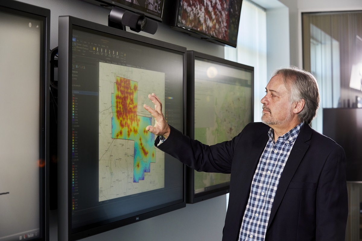
At play is a formidable geographic information system (GIS), the result of a partnership with GIS worldwide industry leader ESRI. It can process tens of millions of records in just minutes, analysing spatial and geographic datasets at an individual level, bringing to light the patterns existing in different populations – and highlighting how where a population lives can shape its lifelong health trajectories.
Read on for a snapshot of some of the fascinating – and illuminating – studies from the team.
PLACE AND METABOLIC SYNDROME (PAMS) STUDY
Home is where the heart is, they say – and the AGeoH-L team has taken a deep dive into the host of complex and intertwined factors that influence cardiometabolic health, ranging from walkability to traffic flow to access to fast food.
The project began at the Sansom Institute for Health Research, University of South Australia, where AGeoH-L Director Mark Daniel, Professor of Epidemiology and Associate Professor Neil Coffee, were based at the time.
“Because we tested the built environment against so many other contextual factors, the project outcomes were significant,” Neil says. “One of the things we found was that the walkability of an area and access to parks is associated with slightly lower cardiometabolic health risks.”
Assistant Professor of Public Health Suzanne Carroll, whose PhD involved analyses of PAMS data, added another dimension to the project by exploring the influence of the social norms generated by the people who lived in an area – eg., if more people living around you are obese, you are more likely to perceive that as a norm.
It’s a collaborative project made possible by the AGeoH-L’s research approach.
“Using the standardised data indicators Mark developed helped us to tell a coherent story with the data,” Suzanne says.
She says that in the research sphere, you can have many different groups applying various analytical methods to data – and this can be a stumbling block for collaboration. The standardised data indicators address that problem, and therefore allow for greater collaborative potential.
This project was made possible by grants from the National Health and Medical Research Council, South Australia Department of Health and other partner agencies.
HEALTH ATLAS: GEOSPATIAL MAPPING PROJECT TO TARGET CARE TO HEALTH HOTSPOTS IN THE US
Funded by the Digital Health Cooperative Research Centre, AGeoH-L researchers are immersed in a three-year project to develop a comprehensive, interactive Health Atlas that evolves in real time.
“This is a truly exciting project, conducted at a level that you can actually identify and predict health outcomes in a population, showcase the role of the built environment in that and then come up with targeted strategies and interventions,” says Neil.
For the project, researchers are working with Medicaid client data, the United States’ federal/state program that helps with medical costs for people with limited income. They will combine built, physical and social environment data with patient information on Medicaid costs and claims, focusing on chronic diseases associated with lifestyle risk factors, like Type 2 diabetes and cardiovascular disease.

Adherence to prescription medication and access to health services are two crucial considerations, with the project able to differentiate between actual and potential access – identifying the gaps so that they can be filled.
“We can see how patients adhere to a medicine regime, what kind of medical services they have access to, and what impacts them to see a doctor or take medicines – for instance, do they live in a neighbourhood with a high crime rate, or do they have poor access – either or both of longer distances and/or greater drive time – which could affect them accessing their medications and medical care?” says Mark.
“The Medicaid system is about managing the costs involved, but is ultimately focused on providing the best outcome for its clients – the potential to both improve health and save costs is enormous.”
EARLY INTERVENTIONS TO REDUCE THE BURDEN OF DISEASE
A four-year project funded by a Medical Research Future Fund grant, this project will address developmental vulnerability and health inequity among young children (from birth to five years of age) in the ACT.
It will look to drive intervention policy and efforts with a community focus, and will test a local integrated system – including identification, referral and targeted service delivery – to see if it improves child development outcomes.

“A large body of research suggests that the early years of a child’s life have a significant impact on their lifetime health and wellbeing,” says Professor Rachel Davey, Director of the University of Canberra’s Health Research Institute (HRI).
“This project will foster increased collaboration across academic disciplines, policy makers, social and community services, and health services to support positive behaviour change to maximise children’s development.
“For family and children’s services to be effective – especially for at-risk children – systems and the programs associated with them must be connected in a collaborative and integrated approach.”
“We are seeking to change the life trajectory of vulnerable children during early childhood, in order to improve health for the next generation.”
The project could improve overall physical health for children, as well as enhancing social competence and improving early childhood education attendance – with its benefits projected to extend beyond the current cohort.
AGeoH-L researchers will collaborate with the Australian National University, University of Wollongong and Queensland University of Technology.
KUWAIT GEOSPATIAL HEALTH HUB AND DIABETES REGISTRY INITIATIVE
In partnership with the Dasman Diabetes Institute (DDI) in Kuwait, AGeoH-L researchers are mapping the various factors that may be driving Type 2 diabetes in the country. The huge project – with funding in the region of $2.9 million – uses spatial epidemiology to peel back the layers of a disease which has become a cause for concern in many Arab countries.
It’s the first geohealth research hub in the region.
“A high prevalence of Type 2 diabetes has been found in Kuwait’s population, with about 20 percent diagnosed as diabetic or pre-diabetic,” Neil says.
“This project is about geo-enablement and exchange, as we link the health outcomes to where people live, and focus on prevention and targeted interventions.”
It’s important to keep things in context, he adds – for instance, walkability is not a relevant factor in Kuwait.
“Physical activity needs more planning on their part, the transport system is very different, as are food environments and open spaces and with Kuwait’s desert location, there aren’t a lot of green parks there,” Neil says.
The local diet is one of the biggest focuses of the project. To understand what underpins the local approach to food, researchers look at datasets at both population and individual levels, taking into account what kind of food people are buying, as well as feedback on these choices, in the context of the larger built environment.
The linkages between health outcomes and home will allow targeted interventions to be put in place. These can include tools to empower consumers to make better choices from the outset, thereby influencing the development of the disease.
The FoodSwitch mobile app from DDI, in partnership with the George Institute of Global Health, is one such tool, which provides nutritional information on a food product scanned – as well as a healthier alternative a consumer may wish to substitute it with.
This project is ongoing into 2022.
ACTIVE STREETS: EVALUATION AND EVOLUTION
An ACT Government initiative, the Active Streets for Schools program is all about encouraging kids to walk to and from school via identified safe routes. The program involves increased safe crossings and upgraded footpath connections, as well as wayfinding signage and maps underpinned by GIS technology.
As the built environment evolves, these elements need to as well, so in collaboration with Transport Canberra, Faculty of Health researchers started auditing the maps about 18 months ago.
“We first developed a paper-based audit tool, which was used by UC students on placement to audit the routes,” Suzanne says. Running the resulting feedback through the lab, the researchers used it to digitise the tool, turning it into a downloadable app.
“With this audit app, you can walk the routes, take photos of any potential hazards, which will then be geotagged – because it’s very important to make sure the paths stay clear and safe,” Suzanne says.
Having more kids walk to school also reduces traffic congestion and creates safer environments around schools.
“So looking ahead, we plan to draw on built environment data to include more designated drop zones slightly further away from the schools, so that kids can be dropped off and then walk the rest of the way,” says Suzanne.
The researchers plan to engage with parents to investigate what they might be looking for in these potential drop zones, to help develop better support and strengthen the program further.
BREAST CANCER SCREENING
The importance of regular breast screenings to detect cancer is common knowledge today, with Australian women aged between 50 and 75 receiving an annual invitation for free screening – but how does location and access to screening clinics impact the uptake?
Partnering with the NSW Cancer Institute, the AGeoH-L team explored that question at rural, urban and suburban screening clinics, both in fixed locations and mobile clinics.
“We were looking for the rates of uptake for screening, rather than examining individual behaviour,” says Suzanne.
In this way, researchers were able to investigate how areas of residence – and the norms and socioeconomic factors tied into them – affect screening uptake. They also considered the influence of built environment factors around screening clinics – eg, whether a clinic was located within walking distance of a bus stop or train station, as well as incorporating data on traffic flow to see how long it might take to get to a clinic.
“This information will help the NSW Cancer Institute optimise its strategies for screening to improve service delivery,” Suzanne says. “For instance, we found that women who don’t speak English at home have a lower uptake of screening, so one strategy could be to provide multi-lingual advertising and services where that is relevant.”
The research also provides crucial insight into the optimal placement of both fixed and mobile screening clinics, drawing on predictive modelling for the best possible outcomes for screening rates.
With the work ongoing, Mark says that the research is suggesting that screening rates appear to be greater where screening venues are more conveniently located, for example, at a shopping mall with shops and other services, where “trip-chaining” of multiple errands can be done, and parking or public transit may be more convenient than at a radiology clinic in a major hospital complex.
IMPROVING SPATIAL DATA LINKAGES
This project was run in collaboration with the Australian Bureau of Statistics (ABS).
The ABS collects vast amounts of data via means such as the National Health Survey (NHS). The NHS collates information about the health and wellbeing of people in Australia, including long-term health conditions, health risk factors and demographic and socioeconomic information.
These data tend to be aggregated to a large spatial unit prior to release – a practice that can cause the loss of significant nuance and detail, says Suzanne.
“To understand the relationship between place and health, we need to know what is around a person’s house and how it affects the people who live there,” Suzanne says, an important consideration in urban planning.
Working with data collected from the 2017/2018 NHS, researchers at the lab created layers of built environment data such as locations of supermarkets or health services. They then provided these to the ABS, which could link these layers to individual place of residence data.
“We did this without having the individual addresses, to protect privacy,” Suzanne says.
Creating these data layers, which can be transposed in a variety of combinations according to need, adds research value and widens the potential parameters of how it can all be used.
The AGeoH-L team is already hoping to bulk this capacity up even further with the next NHS in 2020-2021, having included questions of their own to add more built environment and health behaviour components.
THE ENRICH PROJECT: ENVIRONMENT AND REMOTE INDIGENOUS CARDIOMETABOLIC HEALTH
Working with 104 Indigenous communities in remote Northern Territory areas, the AGeoH-L team investigated the impact of the built (buildings, services), physical (climatic), and social (employment, education, demography) environments on cardiometabolic outcomes and infectious diseases in this project funded by grants from both the National Health and Medical Research Council (NHMRC), and the Australian Research Council (ARC).
The largest-scale study of its kind nationally, the project aimed to generate a strong base of evidence for more progressive social policies, leading to better health outcomes in the communities.
“Because our study is so much larger, involving an unprecedented number of remote communities, we can provide a far stronger basis for inference as to what kinds of conditions support community health, thus illustrating that ill health afflicting remote Indigenous Australians is less a problem of people per se and more a problem with the conditions that people live in and experience,” Mark says.
“A lot of the research on Indigenous health in Australia differentiates location simply by denoting whether it is remote or rural or urban, etc,” Neil says.
By averaging everything out though, researchers lose the subtleties of different locations and therefore can’t pinpoint why one community may be doing well in terms of health outcomes, while another could be doing poorly. It’s kind of like seeing the forest as a blob of trees – without being able to tell what kind of trees they are.
When working with Aboriginal communities, Neil says, it can be difficult for researchers to obtain data because past exploitation has led to community suspicion.
“So we engaged with the communities a lot and reported our findings to them – it was important that we worked with them, not just ‘at’ them,” he says.
The study results are now being written up, but Mark says that the data are already underscoring some important points – such as overcrowding within dwellings and lack of or poor quality community infrastructure and services corresponding to higher rates of chronic and infectious diseases.
Words by Suzanne Lazaroo, photos by Madeleine Wood and Lightbulb Studio
Read all about the AGeoH-L in UnCover magazine, also out now in cafes and schools across Canberra.